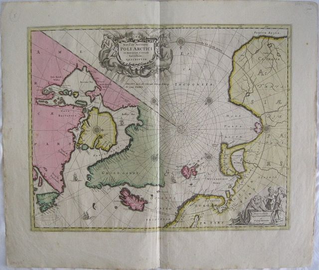
World Celestial & Curiosities: Amsterdam Schenk, Petri & Valk Gerardi c1700. Copper engraved map of the Arctic, the North Pole and adjacent lands from Schenk And Valk's " Atlas Contractus." Original full wash colour; verso blank The map from the plate by Janssonius was originally published in 1637, eventually replaced Hondius' map of the North Pole and became the prototype for many later maps including those of Blaeu. Rhumb lines radiate from the North Pole and several compass roses and ships embellish the chart. A large title cartouche, with two figures and numerous wind heads, conveniently hides the northwest coast of America. Small cartouche depicting men, a polar bear and foxes at lower right with the imprint of Schenk and Valk. Fifth state of the plate with Nova Zembla connected to the mainland with a land bridge and the completed coastline of Spitzbergen . Good impression with bright colour; generally clean; a few spots to blank margins; short centre old split at lower margin [approx 20mm backed with archival tape]. The maps of Schenk and Valk are famous for their full wash colour , however often the pigments, particularly in the greens deteriorated leading to browning and eventually could cause the paper to crack, for this reason it is unusual to see such bright original colour. SCHENCK, Pieter 1660-1718/9 Dutch mapmaker and publisher. Born in Elberfeld, Germany in 1660. Moved to Amsterdam in 1683 where he became a pupil of Gerard Valck, later in 1687 he married Agatha Valck, sister of his associate., thus uniting two great families. In 1686 he is noted in a privilege granted to Petrus Schenck and Gerardus Valck for the printing & sale of their prints. The Valck and Schenk families where active as print sellers, publishers and printers of maps, atlases and architectural drawings as well globes. They accquired plates from the stock of Johannes Janssonius and also of Visscher reissuing several maps of Janssonius' "Atlas Novus "from 1683-94 and published an Atlas titled" Nova totius Geographia" in 1702. The best known of the joint Pieter Schenk & Gerard Valck publications were the second edition of Andreas Cellarius's " Celestial Atlas Harmonia Macrocosmica'" 1708 and an edition of Jan Jansson's "Novus Atlas" entitled the "Atlas Anglois" published in London by David Mortier in 1715. Pieter Schenck the Elder's earliest cartographic productions were a number of maps after Nicolas Sanson published in a composite Atlas, "Atlas Contractus or Atlas Minor" c.1696. He also published a further composite Atlas, "Atlantis sylloge compendiosa," c.1702. Other works included his famous Atlas of one hundred town views," Hecatompolis" [1702];" Le Theatre de Mars "[1706]; and the "Schouwburg van der Oorlog" [1706]. Koeman III,page 115 Sche 2/ Val1. World Celestial & Curiosities North Pole Poli Arctici