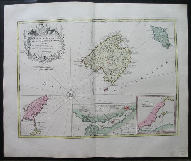
Europe: Amsterdam. Covens et Mortier c1741. Copper engraved map of the Balearic Islands after Bellin from Covens & Mortier's " Nieuwe Atlas, Inhoudennde vier Gedeeltens der Waereld.. " Original full wash colour; verso blank. The map shows all four islands with insets to lower right showing the Port of Mahon :Plan du Port et de la Ville de Mahon et des forts and a small map showing the position of the Islands off the coast of Spain. Decorative cartouche to upper left with scale below and compass rose to sea. Dark impression; bright full wash colour; printed on heavy paper, Covens & Mortier as a firm existed between 1721-1778, taking over the business of Pierrre Mortier. Johannes / Jean Covens and Cornelius Mortier were brothers- in- law following the former's marriage to Mortier's sister Agatha in 1721, when they also formally went in to partnership. Under the Covens and Mortier imprint, Cornelius and Jean republished the works of the great 17th and early 18th century Dutch and French cartographers De L'Isle, Allard, Jansson, & De Wit. The firm would become one of the most prolific Dutch publishing concerns of the 18th century. The company would pass down through the Covens family as Mortier had no children, changing the name to Covens & Zoon until Pieter Mortier IV a great grandson of the original founder joined the firm and saw the name restored to Mortier Covens & Zoon. ( See Koeman I p45). Jacques-Nicolas Bellin (1703-1772) was one of the most important and prolific French cartographers of the mid-eighteenth century, in the service of the French Hydrographical Office. He was appointed the first Ingenieur Hydrographe de la Marine, and also Official Hydrographer to the French King. Bellin was responsible for an enormous output of charts and maps. In a large folio format, he issued a volume of sea-charts of France, the Neptune François, and several sea-atlases of the World, including the Atlas Maritime and the Hydrographie Française. These large charts were amongst the best of the period and continued being reissued throughout the second half of the eighteenth century. In smaller format, he issued the Petit Atlas Maritime (1764),which contained 580 detailed charts, as well as maps to illustrate l'Abbe Prevost's Histoire Generale des Voyages (1746-1757). Bellin also produced a substantial number of important separately issued maps, particularly reflecting continuing discoveries and political events in the Americas. Koeman I: C&M 8:68, [C&M 10 & 11] Europe Spain & Portugal Balearic islands Majorca Minorca Ibiza Formentera